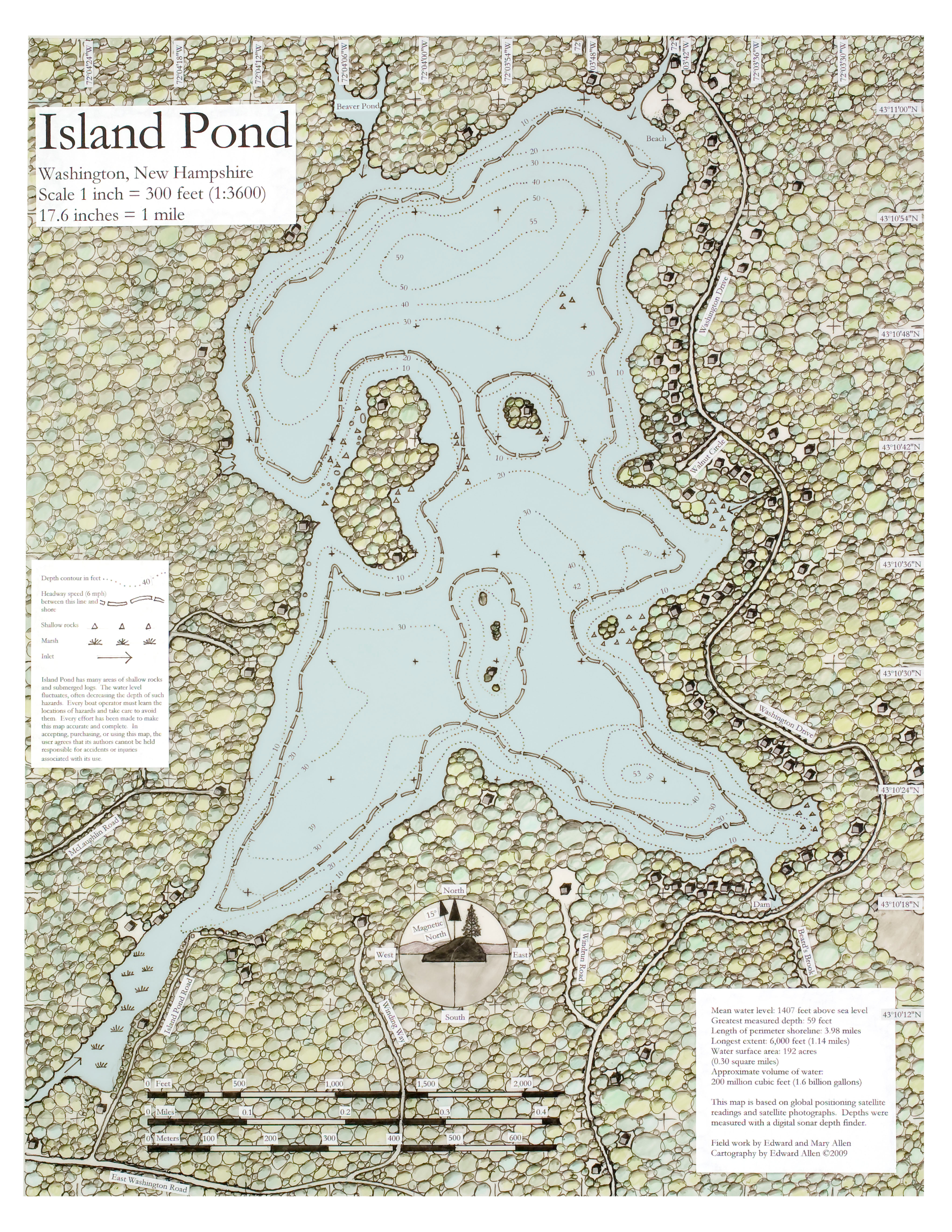
Several years ago, we decided to take on as a retirement project the preparation of an accurate map of Island Pond. Our intent was to occupy ourselves with an interesting project for an extended period of time, and to learn more of the secrets of the lake as we did so. To our surprise, we are not retired yet, and the map is finished.
Modern technology made it a lot easier than we expected it to be. We started mapping with a plane-table surveying outfit in our cove, which made it clear that field work with this traditional method would take many months to accomplish. We purchased a handheld GPS (Global Positioning Satellite) device, and discovered that it was easy to take readings along the shoreline, roadways, and other features to an accuracy that was about the thickness of a pencil line at the scale of the map. We did this primarily while the lake was iced over, which made access easy.
We had plotted about half of the shoreline by this means when Google Earth came to our attention. We printed a satellite photo of Island Pond from this source, enlarged it to the scale at which we were plotting the GPS locations, and laid our developing map over the photo. They matched perfectly! From that moment, we worked primarily from the photographs.
A lot of work remained to be done on foot. Because of dense tree cover, many of the houses couldn't be located on the photographs. We felt it was best not to trespass on private property, so we estimated the distances to each house from a GPS location on the road. As a result, house locations are approximate and house sizes and orientations are symbolic only.
We made numerous expeditions by canoe to every area of the lake to measure water depths. One of us took readings with a sonar depth finder, while the other recorded each sounding and its GPS location. The depth soundings were plotted on our working map. Then a web of straight lines was drawn between adjacent sounding locations, and points on the contours were located by interpolation between the sounding locations on each of the lines. These points were connected by hand to create the contour lines of depth.
The map was traced freehand in ink on semitransparent Mylar drafting film. On a Mylar overlay, colored pencils were used to add the tree colors. The typeset areas of the map were done by computer and glued to the mylar. Then the two layers were photographed together, and the blue of the lake was added in Photoshop.
We hope that you will find the map useful and attractive.
Mary and Ed Allen
PLEASE DO NOT REQUEST MAP COPIES FROM US.
You are welcome to make as many copies as your wish by accessing the WLA web site, downloading the map file free of charge, and printing it either on your own printer or at a copy center such as Kinko's or Staples. If you're not computer literate, the copy center people should be able to download it for you.
[webmaster: clicking on the image above, or the links below will get you to a full sized (4080x5280) "JPEG" file.]